Backpacking Arches National Park (Trip Report)
After spending numerous days in Arches National Park over the past few years, I have always wondered what existed in the parts of the park not visible from the well established trails. With only the time for a quick weekend trip, I decided it was time to find out. Planning for the trip was limited to a quick searches online, and I was suprised to discover that I could not find any info for backcountry access in the park outside of what is offered on the website for the park. It would appear that very few people travel here and thus far, there have been very few reports from those who have. This lack of information peaked my interest even further, not knowing what to expect. A quick call to the park rangers didn't do much to help plan either. The rangers gave the impression that there was very limited area in the backcountry as defined by the limits of where tents are allowed (see park site for rules). However, they did mention that there is no limit to the number of permits distributed and no need for reservations. With the little bit of info I gathered, I bought the availabel USGS maps and set my mind to discovering what exists off the beaten path in this incredible park.
Day 1 - Departure
Thursday April 1, 2010
With a full day of work under our belts, we managed to get the car loaded up and ready for departure by 5:30. Only one major obstacle remaining, I-70 at Vail Pass closed around noon for accident clean up. Although the main route to UT was closed, we still climbed in with hopes the road woul open before we finished a quick dinner in Frisco. Unfortuneatley, luck was not on our side, and the detour sent us over Freemont Pass, towards Leadville in a blizzard. Upon arrival in Leadville, Hwy 24 back to I-70 had just been closed for simmilar problems as the initial I-70 closure. With the snow continuing to pound the high mountians the highway patrol closed the road which would return us to I-70, forcing us to spend some not so quality time in Leadville. After debating a possible assault of Monarch pass to the South (also with chain restrictions) we determined the best approach would be to sleep in the back of the car for a while and check the roads again. Within an hour of falling asleep, the police were knocking on the window to inform us of the road re-opening back to I-70 and the re-opening of Vail Pass. With hope restored that the weekend was not lost, we took off for the desert. With the loss of time to closed roads, we pulled into the No Name rest area in Glennwood Canyon a little after 1 am and decided to call it a night.
Day 2 - Arrival, permits, and entrance
Friday April 2, 2010
Waking early, we headed for the Park with only one more stop, Burger King for some good old breakfast and coffee. A quick stop at the ranger's station for brief rundown of the rules and regulations before we could get our permit, and for the first time in the area, none of the available rangers ha
d ever been out to the area we intended to visit. Although the one helping us did make sure that we knew to "dig a hole and drop a rock." We grabbed our permit and headed straight for the D

evils Garden parking lot at the end of the road, where we would leave the car for the next few days. Our intended path was along the main trail past Landscape arch (left). From here the trail begins its first and only real climb, as it head up towards the fallen Wall Arch. At the top of the hill, the the trail splits with a quick off shoot trail leading to two more arches which we decided to visit. The

first being Navajo Arch which doesn't give much of a view, and the second being Partition Arch (right), which is perched on the cliff above Landscape Arch and provides a great lookout from high above the deser floor. After a quick stop to take in the view and snap a number of pictures, we headed back for the main trail in order to continue towards our final destination. The hike from here takes an in

teresti
ng path over the top of one of the large fins, and decendes down towards the overlook for Black Arch, and then continues on toward one of the most scenic arches in the park, Double O Arch (left). After a quick stop, it was time to be moving again. From here we switch

ed from the well traveled Double O trail, to the Primative Trail, and in doing so we left the majority of the other visitors behind. This trail is significantly less defined, and much less maintained. With the fins appearing to spread out just a little, we decided it was time to leave the trail behind all together. This would be the last time we saw another person in the park until we were almost back to the car. With all of the rules for backcountry travel, we managed to snake our way back through two of the fins (right) through a couple of dry stream beds to where we would eventually decide to put the tent. With "special dirt" everywhere we were forced to find a relatively flat rock which would become our bed for the next two nights.
Day 3 - Exploration
Saturday April 3, 2010
Awaking to nothing but the sound of the birds and the first light of the sun streaming into the small canyon (right), we decided it was time to leave the sleeping bags behind, eat some breakfast and take in the sights of the area. We quickly grab some food and found some sun to enjoy it. With no real plans for the day, we packed a bag and headed out for some exploration. The entire area is filled with small canyons and tons of rock just waiting to be explored, alt

hough some climbing gear would have made the exploraiton a little more interesting, there was plenty to see and do without it. Being early in the year still, some of the potholes were still filled with runoff from the snow melt (left), still taking place, and caused us to detour around and through side canyons we may have otherwise skiped. With all of the canyons looking so similar, it's a wonder that more people have not gotten lost back here. With a quick return to home base for lunch, the weather quickly changed, and changed our plans with it. Although the clouds stayed away, the wind quickly picked up and even turned our tent with all of our gear inside upside down.
Day 4 - Exit, and returnSunday April 4, 2010 (Easter)
Another early morning with just one major goal, return to Denver in time to get enough sleep to head back to work on Monday :( With the sun starting to light the canyon, we quickly packed the gear and grabbed some food on the go. The begining of our exit would follow the route we came in assuming we could find it again. Once we arrived back at the Primitive Trail, hung a left and headed in the opposite direction from where we had arrived from. From here, we only came accorss one other group, a mom and her son out for a morning run, until we arrived back at the trail merge. From here it was just a quick jaunt out to the car where we quickly dropped the gear and found some nice clean clothes for the long drive back. All in all, a great trip, and I plan to return to do some more exploring.
 evils Garden parking lot at the end of the road, where we would leave the car for the next few days. Our intended path was along the main trail past Landscape arch (left). From here the trail begins its first and only real climb, as it head up towards the fallen Wall Arch. At the top of the hill, the the trail splits with a quick off shoot trail leading to two more arches which we decided to visit. The
  first being Navajo Arch which doesn't give much of a view, and the second being Partition Arch (right), which is perched on the cliff above Landscape Arch and provides a great lookout from high above the deser floor. After a quick stop to take in the view and snap a number of pictures, we headed back for the main trail in order to continue towards our final destination. The hike from here takes an in
 teresting path over the top of one of the large fins, and decendes down towards the overlook for Black Arch, and then continues on toward one of the most scenic arches in the park, Double O Arch (left). After a quick stop, it was time to be moving again. From here we switch
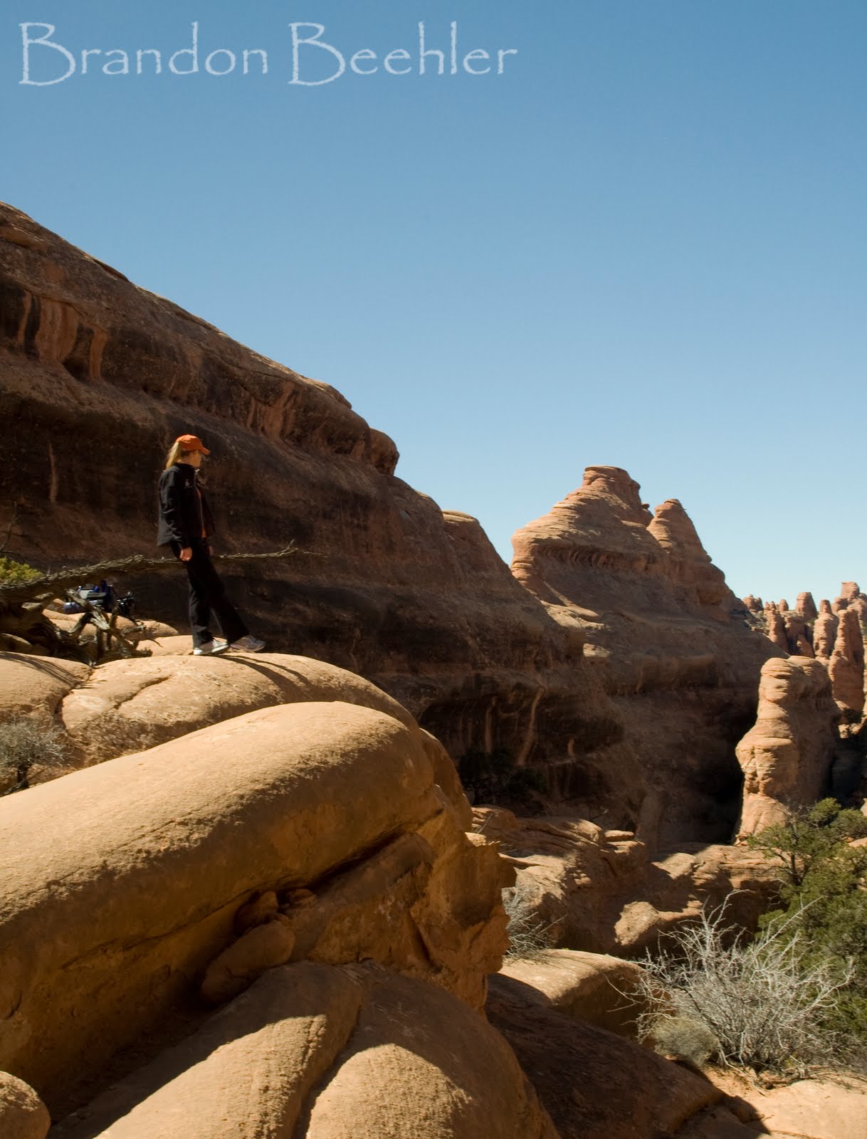 ed from the well traveled Double O trail, to the Primative Trail, and in doing so we left the majority of the other visitors behind. This trail is significantly less defined, and much less maintained. With the fins appearing to spread out just a little, we decided it was time to leave the trail behind all together. This would be the last time we saw another person in the park until we were almost back to the car. With all of the rules for backcountry travel, we managed to snake our way back through two of the fins (right) through a couple of dry stream beds to where we would eventually decide to put the tent. With "special dirt" everywhere we were forced to find a relatively flat rock which would become our bed for the next two nights.
 hough some climbing gear would have made the exploraiton a little more interesting, there was plenty to see and do without it. Being early in the year still, some of the potholes were still filled with runoff from the snow melt (left), still taking place, and caused us to detour around and through side canyons we may have otherwise skiped. With all of the canyons looking so similar, it's a wonder that more people have not gotten lost back here. With a quick return to home base for lunch, the weather quickly changed, and changed our plans with it. Although the clouds stayed away, the wind quickly picked up and even turned our tent with all of our gear inside upside down.
Sounds like a great trip! Thinking about backpacking in Arches this May and found this very helpful since there isn't a lot of info out there on backpacking out there. Just curious, any guess on how many miles it was out to where you camped?
ReplyDelete